


2025-08-02_09h50m46_SityTrail - 2413193 - circuit-de-la-ferte-alais

jpcccb
User
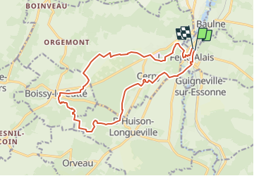

Length
16.4 km

Max alt
145 m

Uphill gradient
199 m
Km-Effort
19.1 km

Min alt
52 m

Downhill gradient
203 m
Boucle
Yes
Creation date :
2025-08-02 07:50:46.146
Updated on :
2025-08-06 11:11:51.16
4h20
Difficulty : Very difficult

FREE GPS app for hiking
 SityTrail
IGN / Geographical institutes
SityTrail Plus
The world is yours!
About
Trail Walking of 16.4 km to be discovered at Ile-de-France, Essonne, La Ferté-Alais. This trail is proposed by jpcccb.
Positioning
Country:
France
Region :
Ile-de-France
Department/Province :
Essonne
Municipality :
La Ferté-Alais
Location:
Unknown
Start:(Dec)
Start:(UTM)
452115 ; 5370353 (31U) N.
Comments